
Thin Line of Security: Border Infrastructure Development and the Ecology in the Sikkim Borderlands
Abstract
A cold desert, situated at an average elevation of approximately 4,500 meters in the Sikkim Trans-Himalaya, the Tso Lhamo region has a unique geography and ecology. It occupies a strategically significant location within the broader context of Sino-Indian territorial dispute, while simultaneously serving as a vital habitat for diverse flora and fauna. As such, the region is a critical site where conservation priorities (environmental security) intersect with—and, at times, come into conflict with—the imperatives of territorial defence (national security), often advanced through state-led infrastructural development. Using the case of border infrastructure development and the fragile ecology of the Tso Lhamo region, the Issue Brief examines the intersection between national security and ecological conservation in the borderlands of Sikkim
Keywords: Himalayan borderlands; national security; environmental security; infrastructure development
Situated in the Eastern Sector of the India-China boundary, Sikkim shares a 220km land border with China and has consequently been integrated into India’s broader infrastructural development along the borders. Key projects in the state include the Sevok-Rangpo Railway Project, targeted for completion by December 2027 (Ministry of Railways, Government of India). This will not just link Sikkim to the national railway network, but also assist in the development of the strategically significant National Highway (NH-717A). In addition to these major initiatives, several smaller yet critical infrastructure projects have been undertaken. These include the construction of strategic roads by the Central Public Works Department (CPWD), alongside works carried out by the Border Roads Organisation (BRO), as well as the establishment of border outposts in the Tso Lhamo region at the northern tip of the state.
The Tso Lhamo region which lies in the northern borderlands of Sikkim is characterised by a rich and distinctive high-altitude ecology. Despite covering an area less than 400 square kilometres, the region supports a unique collection of flora and fauna, including several endangered species native to the Eastern Himalayas. Further, the region lies between two ecological conservation areas—the Khangchendzonga National Park and Biosphere Reserve and Shingbha Rhododendron Sanctuary.
In this context, the region emerges as a critical site where conservation priorities (environmental security) intersect and at times conflict with the imperatives of national security and defence which are pushed through state-led infrastructural development. This Issue Brief examines the intersection of the border infrastructure development and the fragile high-altitude ecology of Tso Lhamo region in the borderlands of Sikkim. More broadly, this case illustrates the tension within the wider security discourse in the Himalayas, where national security frequently comes into conflict with the goals of ecological conservation and environmental protection, i.e., environmental security. The Issue Brief further attempts to examine this tension and provides policy suggestions where the dimensions of security can be reconciled and pushed forward.
Border Infrastructure Development in an Ecological Sensitive Region
The Tso Lhamo region is home to over 65 glacial lakes, 12 glaciers, and four peaks rising above 6,700 metres. Joseph Dalton Hooker, a British explorer who travelled through the region in the 1830s, documented its rich assemblage of flora and fauna, including several species endemic to the Eastern Himalayas (Hooker 1854) listed under ‘Endangered’ of Schedule I of the Indian Wildlife Protection Act (IWPA), highlighting the ecological significance of the high-altitude landscape.
Image 1
The Tso Lhamo Cold Desert Landscape
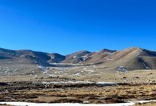
Source: Author, 2025
The Tso Lhamo region is home to Tibetan argali (nyan), Tibetan gazelle, kiang, and blue sheep (Chanchani et. al 2011, 367). Further, the Eurasian lynx, wolves, and sand foxes are the major predators in the region. Among the smaller herbivores, Himalayan marmots, (Marmota Himalayana), plateau pikas (Ochotona curzoniae), and woolly hares (Lepus oiostolus) are found in the region (Chanchani et. al 2011, 372). This high-altitude landscape also harbours diverse birds including migratory waterfowl (Ganguli-Lachungpa and Rahmani 2003).
The Tso Lhamo region supports not only rich, wild flora and fauna but also pastoral livelihoods, with domesticated yaks and sheep herded by the nomadic Dokpa community. The Dokpas have long been integral to the region’s ecological system, with their mobility and grazing practices shaping the high-altitude landscape. Alongside civilian presence, the region also hosts a significant concentration of state actors, including the Indian Army, the Indo-Tibetan Border Police (ITBP), and the BRO, reflecting its strategic importance within India’s border security framework.
Historically, numerous caravans of traders, missionaries, and officials passed through the region either north into Tibet or south into Sikkim. Interestingly, it was here that the British official, Colman Macaulay, met the Dzongpen (Tibetan Governor) of Khamba Dzong in 1884, to discuss the prospect of opening up Tibet to the British. This subsequently led to the signing of the Anglo-British Convention of 1890 which demarcated the Sikkim-Tibet border.
Along with its rich ecology, the region also has strategic importance because of the larger India-China rivalry and territorial contestation. The region is part of the watershed that determines the border between India (Sikkim) and China (Tibet Autonomous Region). Further, the flat terrain of the Tso Lhamo region unlike the typically rugged Himalayas allows India to deploy armoured units that can threaten Chinese infrastructure build-up and troop mobilisation on the Tibetan side in the Chumbi Valley (Joshi 2021). The ‘disputed’ areas such as Naku La and the Finger Area in the Sikkim sector also lie in this region.
The region’s strategic importance has resulted in a wave of border infrastructure development projects on the Indian side including a large network of roads (for the easy movement of troops and military equipment), forward posts, and acclimatisation centres. These developments require significant manpower and heavy equipment. Both have been brought in from outside into what is otherwise a sparsely populated and underdeveloped region. Table 1 shows the list of border infrastructure projects in and around the Tso Lhamo region. These projects are in addition to the existing border infrastructure such as the development of NH 310AG under the BRO.
Table 1
Border Infrastructure Projects around the Tso Lhamo region (2019–2025)
| S. No. | Details of the Project | Year (Sanctioned) |
| 1. | Strategic Road Connectivity (Dorjila) | 2019 |
| 2. | Strategic Road Connectivity (Kerang-Olatin) | 2021 |
| 3. | Border Out Post (BOP) at Kerang | 2022 |
| 4. | Border Out Post (BOP) at Gorala | 2022 |
| 5. | Border Out Post (BOP) at Zanak | 2022 |
| 6. | Staging Camp at Thangu | 2022 |
| 7. | Acclimatization Centre at Gaigong | 2022 |
| 8. | Strategic Road Connectivity (Muguthang) | 2023 |
Source: Created by the Author based on information from the Integrated e-Governance Portal for Automation, Streamlining and Effective Management of Process Related to Plantation and Other Forestry Works Under all Schemes at https://egreenwatch.nic.in/Portal.aspx
The border infrastructure development can be located within the larger strategic shift in India’s border policy. For example, the clearance for the construction of 608km of roads along the India-China border by the Cabinet Committee on Security in 2006 marked a significant shift in India’s Himalayan border policy vis-à-vis China. This decision signified a transition from the earlier defensive approach adopted by India in the aftermath of the 1962 Sino-Indian conflict, during which the country deliberately refrained from developing infrastructure closer to the LAC (Bose and Singh 2025). Following this strategic shift, India initiated a comprehensive effort to revamp and expand its border infrastructure, including the construction of strategic roads, air bases, railway connectivity, and border outposts.
State Security or Environment Security?
Border infrastructure development in the region carries significant ecological ramifications. For instance, road construction activities at Muguthang and Dorjila under the CPWD employ more than 300 labourers[i] while the BRO also maintains a substantial workforce in the region. Although many of these workers do not reside permanently at high altitudes and commute from lower areas such as Thangu,[ii] their cumulative presence exerts pressure on the region’s sensitive ecology with increased instances of hunting and collection of wild resources such as edible mushrooms and medicinal plants—resources that are integral to local biodiversity and wildlife sustenance.[iii]
The growing human footprint has also contributed to habitat reduction, leaving wildlife with shrinking grazing areas. This has increasingly pushed animals into closer proximity with human settlements, resulting in forced cohabitation that may have long-term adverse effects on their survival and reproductive patterns. Further, increased human-wildlife conflict has also been reported. Nima Gyaltsen (Dokpa), who has been herding yaks for the past five decades, notes an increasing number of incidents in which Tibetan wolves and snow leopards have attacked livestock, at times also posing a threat to the lives of the Dokpa pastoralists.[iv]
Additionally, large-scale infrastructure construction has accelerated topsoil depletion, thereby reducing resource availability and disrupting the food chain of the wildlife in the region. The construction of roads, defence cantonments, and BOPs at Tso Lhamo further encroaches upon meadows and natural habitats critical for wildlife (Rawat 2025, 15). These adversely impact water availability for wildlife in the region (Chanchani et. al 2011, 357). For instance, the defence cantonments at Taling, Gaigong, and Dongkung are situated in close proximity to, or upstream of, key water sources, often contributing to their pollution.[v] The diversion of the Mirdo spring, which feeds Gyam Tsona Lake—an important site for animal breeding—has reportedly led to the shrinking of the lake into a small pond (Ganguli-Lachungpa 2002). Sonam Tshering,[vi] who has been a witness to the development of Tso Lhamo region notes that increasing pollution and the drying up of smaller ponds and water sources have been exacerbated by recent construction activities.[vii]
Acknowledging the adverse ecological impacts of border infrastructure development does not necessarily imply that such initiatives should be halted or restricted. In the context of China’s accelerated expansion of border infrastructure, India has a strategic imperative to correspondingly enhance its own capabilities. Consequently, the development of border infrastructure in this area must be understood as a necessary component of India’s security framework, shaped by the broader dynamics of Sino-Indian territorial contestation.
Balanced Security: A Way Forward
Rather than viewing border infrastructure development and ecological preservation as mutually exclusive, the real advantage lies in reconciling strategic imperatives with environmental sustainability in the fragile borderland of Tso Lhamo. Reconciling these two dimensions of security is necessary, as it allows policymakers to safeguard the region’s rich ecology without compromising on national security imperatives. Protecting and conserving the ecology of the Tso Lhamo region is particularly important because it indirectly ensures water security and regulates river systems. Moreover, ecological conservation contributes to disaster mitigation by stabilising the soil and preventing landslides. Any adverse ecological impact could also severely undermine the livelihoods of the highland Dokpa communities.
Given Tso Lhamo’s ecological significance, there is an urgent need to formulate a long-term conservation strategy. Adopting a reconciliatory approach—a ‘middle way’—that integrates strategic security with ecological sustainability can effectively address and safeguard both dimensions of security.
The Indian Army and the ITBP, which maintain a significant presence in the region, can play a crucial role in reconciling strategic imperatives with ecological conservation. The proactive and sustained involvement of these security forces is essential for preserving the fragile ecosystem of the area. In many ways, their presence in this restricted zone has already contributed to limiting unregulated access by casual visitors, controlling tourism activities, and regulating livestock grazing—measures that have had a positive impact on the region’s ecology to some extent. Beyond Gaiyong, in the Tso Lhamo region, tourists are required to present their permits to the Indian Army, which controls and determines the areas accessible to them. At present, access is restricted to the Gurudongmar region, and tourists are not permitted beyond this point.[viii] Even locals require permits to visit the area.[ix] Additionally, the Indian Army has increasingly moved away from practices such as hunting through targeted sensitisation programmes. Initiatives such as the Ecological Task Force of the Territorial Army can be further mobilised to undertake structured conservation efforts in the region.
Beyond the role of defence forces, the active participation of local communities—particularly the Dhokpas and traditional institutions such as the Dzumsa is equally vital. Strengthening awareness and fostering community-based conservation practices can help align ecological sustainability with national security objectives. The Dzumsa, in particular, can serve as an effective local governance mechanism to promote ecological awareness among the Dhokpa community and regulate the activities of local residents who frequently access the Tso Lhamo region.
Image 2
A Migratory Bird seen in Tso Lhamo Lake
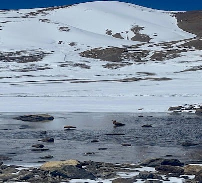
Source: Author, 2026
In addition to these institutions, the Sikkim State Forest Department—which has implemented several conservation initiatives—can play a pivotal role by bringing its technical expertise in ecological conservation and in preventing the degradation of the region’s flora and fauna. With its longstanding presence and institutional experience in the area, the department is well-positioned to contribute meaningfully to conservation efforts.
Ultimately, safeguarding the ecology of the Tso Lhamo region without compromising national security and reconciling these two imperatives depends on robust coordination among the various stakeholders operating in the region. Effective consultation, along with forging and sustained maintenance of strong partnerships between government agencies, local communities, and non-governmental organisations, will be crucial in shaping responsive and balanced policy frameworks.
At the micro level, targeted awareness and regulatory measures—particularly among labourers and workers engaged in border infrastructure projects—can help mitigate several ecological concerns. As noted earlier, the large number of workers associated with these projects increases human presence in the region, leading to disturbances in wildlife habitats. Waste generated by these activities further exacerbates ecological degradation. For example, huge piles of plastic waste (Maggi noodles packets and Coke bottles) were seen around border infrastructure project sites at Muguthang and Dorjila during field visits.[x] In this context, promoting ecological awareness among workers, alongside implementing regulations governing their movement and activities, can be employed to minimise environmental impact without hampering the infrastructure development in the region. Loden Lachenpa, an employer of a significant number of casual paid labourers working under the BRO in the Tso Lhamo region, emphasises the practice of instructing workers to carry back waste—especially plastic—to designated camps for disposal, undertaken in coordination with the Indian Army and the local institution of Dzumsa.[xi] Such policies and regulations should be strictly enforced.
In addition, legal and regulatory frameworks such as the Forest (Conservation) Amendment Act, 2023 and the Environment Impact Assessment (EIA) Notification, 2006 have been instituted to mitigate the adverse ecological impacts of infrastructure development. However, the application of the Forest (Conservation) Amendment Act, 2023 remains limited in regions such as Tso Lhamo, where projects are often exempted on grounds of defence and national security. Nevertheless, these legal frameworks continue to serve as important benchmarks, guiding environmental considerations and setting standards for assessing ecological impacts arising out of infrastructure development projects, particularly in ecologically fragile and sensitive regions like Tso Lhamo.
Conclusion
In India, the traditional conception of security—centred on sovereignty and territorial integrity (national security)—continues to dominate over other paradigms, including environmental security. These are clearer in the borderlands, where there is a clear hierarchy of security priorities; national security is given importance when compared to other security concerns whether environmental or ecological. The Tso Lhamo region exemplifies this dynamic interplay, where processes of border securitisation and militarisation, reinforced through expanding infrastructure development have increasingly overshadowed ecological and environmental concerns.
Offering privilege to one dimension of security at the expense of the other is neither viable nor sustainable in the long term especially in an ecologically sensitive region like Tso Lhamo. As such, embedding ecological sensitivity within the broader national security paradigm, ensures a balanced approach where the pursuit of national security does not undermine the fragile ecology of the region. This integrated approach is essential for fostering
ENDNOTES
[i] Author’s fieldnotes, 12 December 2025, Thangu.
[ii] Author’s fieldnotes, 12 December 2025, Thangu.
[iii] Author’s fieldnotes, 20 October 2025, Thangu.
[iv] Interview with Nima Gyaltsen, 12 January 2026, Lachen.
[v] Author’s fieldnotes, 21 October 2025, Thangu.
[vi] Sonam Tshering owns more than 100 yaks and their grazing areas mostly lie around Tso Lhamo region during the winter season.
[vii] Interview with Sonam Tshering, 22 October 2025, Thangu.
[viii] Author’s fieldnotes, 12 December 2025, Thangu.
[ix] Interview with Pipon Bandhu Lachenpa, 10 January 2026, Lachen.
[x] Author’s fieldnotes, 21 October 2025, Muguthang.
[xi] Interview with Loden Lachenpa, 20 October 2025, Thangu.
REFERENCES
Arrawatia, M. L. and Tambe, Sandeep (Eds). 2011. Biodiversity of Sikkim: Exploring and Conserving a Global Hotspot. Gangtok: Information and Public Relations Department, Government of Sikkim. http://sikkimforest.gov.in/biodiversity-of-sikkim.htm
Bose, Pratik and Singh, N.K. 2025. “India’s Road Construction Activities Along the Sino-Indian Border in Arunachal Pradesh: Issues and Challenges (Post-2014).” Asian Journal of Political Science. Vol No. 34, No. 1. 152–74. https://doi.org/10.1080/02185377.2025.2528607
Das, Pushpita. 2021. India’s Appraoch to Border Management: From Barriers to Bridges. New Delhi: KW Publishers. https://www.idsa.in/system/files/book/indias-approach-to-border-management.pdf
Inskipp, Tim and Lachungpa, Usha. (n.a). “Important Bird Areas in India—Sikkim: Tso Lhamo Plateau-Lashar-Sebu La-Yumesamdong Complex.” Forest and Environment Department. Government of Sikkim. http://sikkimforest.gov.in/docs/IBA/sk10.pdf
Ganguli-Lachungpa, Usha. 1996. “Unusual Congregation of Nayan Ovis Ammon Hodgsoni Blyth at Gyam Tsona, North Sikkim.” Journal of Bombay Natural History Society. Vol No. 93, No. 2. 292. https://dn721804.ca.archive.org/0/items/biostor-152263/biostor-152263.pdf
Ganguli-Lachungpa, Usha. 2002. “Avifauna of Trans-Himalayan and Alpine Grasslands in Sikkim, India’. In A.R. Rahmani and G. Ugra (Eds). Birds of Wetlands and Grasslands: Proceedings of the Salim Ali Centenary Seminar. Mumbai: Bombay Natural History Society.
Hooker, J.D. 1854. Himalayan Journals, Or, Notes of a Naturalist in Bengal, the Sikkim and Nepal Himalayas, the Khasi Mountains &C. London: John Murray. https://www.google.co.in/books/edition/Himalayan_Journals_Or_Notes_of_a_Natural/KHYOAAAAQAAJ?hl=en&gbpv=1&pg=PA125&printsec=frontcover
Joshi, Manoj. 2021. ‘The Mystery Behind Claims of India-China Clash at Naku La, Sikkim’. ORF Commentary. https://www.orfonline.org/research/the-mystery-behind-claims-of-india-china-clash-at-naku-la-sikkim
Ministry of Home Affairs. Government of India. ‘Annual Report 2007-08’. https://www.mha.gov.in/sites/default/files/AnnualReport_07_08.pdf
Ministry of Railways. Government of India. “Sevok-Rangpo Railway Project to be Completed by Dec 2027.” https://www.pib.gov.in/PressReleasePage.aspx?PRID=2231092®=3&lang=2
Pranav, Chanchani, G.S. Rawat and S.P. Goyal. 2011. “Ecology And Conservation Of Ungulates in Tso Lhamo, North Sikkim.” In M. L. Arrawatia and Sandeep Tambe (Eds). Biodiversity of Sikkim: Exploring and Conserving a Global Hotspot. Gangtok: Information and Public Relations Department, Government of Sikkim. http://sikkimforest.gov.in/Reports and Publications/Biodiveristy-of-Sikkim/19 Tso Lhamo_351-362 web.pdf
Rawat, G.S. 2025. ‘Rangelands of Indian Trans-Himalaya: Sustaining Ecosystem Services and Pastoral Livelihoods’. G.B. Pant Memorial Lecture-2025. Memorial Lecture No 31. Almora: G.B. Pant National Institute of Himalayan Environment. https://gbpihed.gov.in/PDF/Popular_Lecture/31_Lecture_English.pdf.
About the Author: Dr. Sangay Lachenpa is a former Post-Doctoral Fellow at the Centre of Excellence for Himalayan Studies, Shiv Nadar University, Delhi-NCR. He also serves as Guest Faculty at the Department of International Relations, Sikkim University. He can be reached at [email protected].