
The South Lhonak Lake, Sikkim Glacial Lake Outburst Flood: Impact on the Agro-pastoral Practice and Local Responses
Abstract
In October 2023, Sikkim was hit by a Glacial Lake Outburst Flood (GLOF) following the breach in the embankment of South Lhonak Lake. There was catastrophic damage along the entire stretch of the Teesta River, wiping out land and connectivity infrastructure in addition to the loss of lives. The loss of connectivity significantly impacted the practice of agro-pastoralism, followed by the local communities who inhabit the borderlands close to the Sino-Indian border. This study looks at the impact of the GLOF on the agro-pastoral practice of the upper riparian communities who reside close to the Sino-Indian border. It specifically focuses on the role of local communities and institutions in mitigating and managing mechanisms in dealing with a crisis. It argues that the local self-governance system called the Dzumsa, which controls and fixes the date and time frame for the movement of livestock from one pastoral space to another, is one of the key institutions helping to mitigate the impact of the disaster.
Keywords: Sikkim, Glacial Lake Outburst Flood (GLOF), agro-pastoralism, the Dzumsa, borderlands
Introduction
One of the first videos of the Glacial Lake Outburst Flood (GLOF) of the South Lhonak Lake on 4 October 2023, which surfaced online, was from a yak herder residing near the Sikkim-Tibet border. The outburst flood would cause catastrophic damage to the entire stretch of the Teesta River. The upper riparian region of the Teesta River belt, which lies at the juncture of the Tibetan plateau on the north and the Himalayas to its south, is an area which has little agricultural land due to the cold and dry terrain. As a result, the region’s general population depend upon a mixture of pastoralism and seasonal agriculture practices for their livelihood.
Tibetan and Bhutia nomads inhabit the upper reaches of the region beyond 14,000 feet in altitude and herd their yaks across the region close to the Sino-Indian border (Luxom et al. 2022). The region, approximately between 6,000 feet and 14,000 feet, practices a mixture of animal herding and seasonal agriculture. The livestock primarily being cow, ox and the hybrid of cow and yak locally known as dzo/dzomo. The demography of the population is dominated by the Bhutias following Buddhism, and the unique feature of the region is that a local self-governance system, the Dzumsa system, governs the area (Bhasin, 2012). The Dzumsa have control over the territory and the people. Agro-pastoralism in the region is adapted to bimodal climatic conditions. As a result, the mobility of the livestock generally follows a seasonal pattern where the livestock are taken to higher altitudes in summer and to lower altitudes during winter. The Dzumsa controls and fixes the date and time frame for the movement of the livestock from one pastoral space to another.
The GLOF of the South Lhonak Lake fundamentally disrupted the movement of these pastoral animals as major bridges connecting the region were swept away. Further, vast swatches of pastoral lands have been washed away, and roads have been wiped out. Villages such as Phim Cheka, Daray, Denya, Latong, Robom and Zeema, which the herders inhabited during winter, have been washed away entirely or partially.
With this background, this study deliberates on the impact of the GLOF of South Lhonak Lake on the livelihood, particularly the agro-pastoral practice of the upper riparian communities who reside close to the Sino-Indian border. The study will further examine the role of local communities and institutions (the Dzumsa) in mitigating and managing the crisis. The upper riparian community and the region here refer to the regions above the Chungthang Dam (Teesta Stage 3).
Figure 1: Map of Teesta River Basin
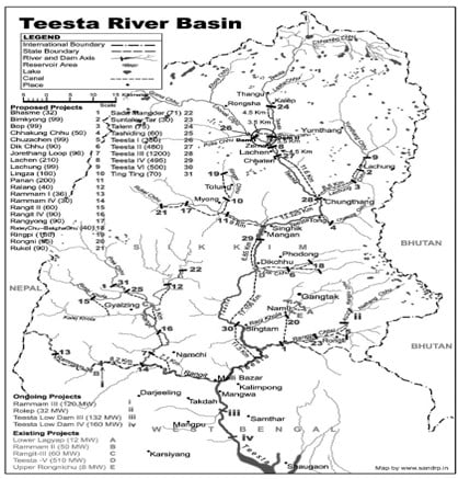
Source: South Asia Network on Dams, Rivers and People (2023)
The Upper Riparian Community of the Teesta River and their Livelihood Patterns
Apart from its rich flora and fauna, the upper riparian region of Teesta River possesses a rich cultural mosaic, being at the crossroads of the Tibetan culture to its north and the numerous multicultural practices to its south. These reasons have resulted in the development of a traditional local self-governance system in the region called the Dzumsa,[1] which functions on par with the Panchayati institutions (Thapa and Sachdeva, 2017). Though the objective of the paper is not to delineate the Dzumsa system, it should be noted that it has a considerable impact due to its overarching and structural control over the community through its various roles and functions. The Dzumsa’s power, authority and responsibility determine to a considerable extent the people’s behaviour, attitudes, and opinions. Its decision-making and implementation mechanisms through fines and punishments are huge factors in determining the region’s economic patterns and ecological and cultural practices (Table 1.1). The Dzumsa, as a result, was one of the critical agencies shaping the community’s role after the GLOF in re-establishing connectivity, pressuring government institutions and in relief and rehabilitation.
Table 1.1 Fines levied under Lachen Dzumsa (2019-2024)
|
Year |
Total Number |
Reasons |
|
2019-20 |
30 |
The maximum number of penalties has been due to the absence from Dzumsa meetings, livestock fines, and the felling of (rhododendron) trees. |
|
2020-21 |
35 |
|
|
2021-22 |
30 |
|
|
2022-23 |
40 |
|
|
2023-24 |
52 |
*The Dzumsa does not keep a written record.
Source: Author’s field notes, 2024.
Agro-pastoralism and trade remained key sources of income and livelihood for the people of the region despite a booming tourism sector. The Dzumsa has been able to regulate the traditional activities associated with these two primary sources of income. Trading activities have, however, changed over the years. Before the 1960s, when the border with Tibet was not sealed off, the local people (Lachenpas and Lachungpas) used to have a vibrant trade with the Tibetans to its north.
The practice of agro-pastoralism dominated the region’s livelihood, especially after the trade was sealed due to the closure of the Sino-Indian border after the 1960s (Farooquee 2010). Tracking the best pasture through the mobility of herds is key to maximising animal nutrition (Silvestri et al., 2012), and as such, strategic mobility, as advocated by the Dzumsa, contributes to the sustainable use, and improvement of forage resources. To have a sustainable mechanism to regulate the crop pattern and grazing lands for the animals, the Dzumsa coordinate the activities, leading to better allocation of resources. These include setting dates for sowing and harvesting crops, and everyone is given adequate time to repair their fences to protect their crops from the animals. The Dzumsa sets and regulates the dates for moving animals from one region to another. All the Dzumsa members have to move together; if anyone is found to be moving early or late, they are fined and punished accordingly.[2] Constraints to mobility represent direct threats to pastoralist’s livelihoods.
Picture 1. Dzumsa deliberating on the GLOF and their plan of action
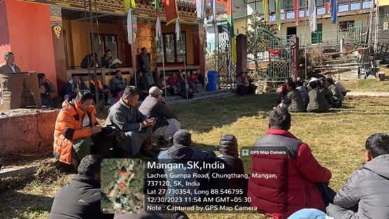
Source: Author, December 2024.
There are primarily two regions set up for summer pasture and winter pasture. Summer pastures lie at a higher altitude (approximately 10,000 feet), while winter pastures lie at a lower altitude (approximately between 5,000 feet and 9,000 feet). The summer pasture area includes villages such as Samdong, Yakthang, Talam, Kalep, Thangu, Chopta and numerous other smaller villages. These villages lie in a valley that was not on the course of the GLOF and, hence, were not impacted by the GLOF. On the other hand, the winter pasture villages such as Phim Cheka, Daray, Denya, Latong, Rabom and Zeema lay on the path of the GLOF and were amongst the first villages to be impacted by the flood.
Table 1.2 Number of Families Residing in the Winter Pasture Villages under Lachen Gram Panchayat Unit
|
S.NO |
Village |
Number of Families |
|
1. |
Phim Cheka |
06 |
|
2. |
Daray |
11 |
|
3. |
Denya |
22 |
|
4. |
Latong |
35 |
|
6 |
Zeema |
15 |
|
Total |
89 |
Source: Data collected by the author through a field survey, 2024.
When the herds move to the summer pasture, winter pasture lands are kept empty (for regrowth); similarly, when the herds move to winter pasture lands, summer pasture lands are kept empty. Along with the two primary pasture lands, there are also pasture lands for the spring and autumn seasons. Such practices contribute to sustainability, allowing animals to get good pasture land all year round, contributing to the sustenance of the place and the herd’s well-being, and providing better economic returns. This is especially important when the higher altitude regions get snowfall, and the herds can be moved to the lower altitudes, saving the cattle from the harsh winter cold.
The GLOF and the Disruption to the Movement of the Livestock and Agriculture
The GLOF of South Lhonak Lake in October 2022 caused extensive damage and destruction to its entire stretch, initially flowing through the Lhonak River before joining the Zeemu River and then meeting the Teesta River. The damage and destruction have been of different types. The upper riparian region saw extensive destruction, particularly in terms of loss of connectivity, washing away of swathes of land, destruction of infrastructure and washing away of livestock.
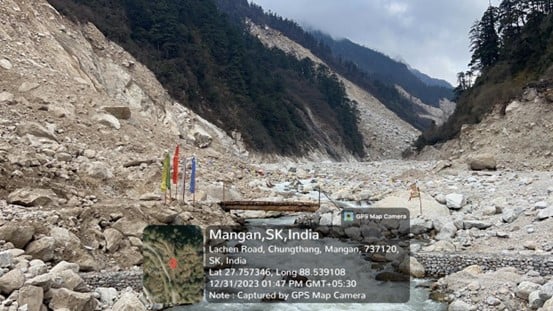
The worst-affected region in the upper riparian GLOF area lies between 6,000 feet and 9,000 feet within the winter pasture area. The region where the Zeemu River joins the Teesta River acts as a border between the summer and winter pasture regions. Villages such as Phim Cheka, Daray, Denya, Latong, Robom, and Zeema are located in this belt.
Picture 2. Daray Village on the right bank completely washed away
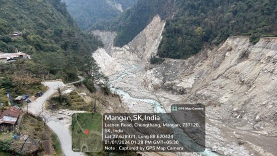
Source: Author, January 2024.
First, the area under discussion saw the destruction of numerous important bridges. Five important bridges, which acted as a primary mode of connectivity connecting the region to the rest of the country, were washed away completely. Numerous smaller bridges were washed away, too. These bridges, apart from connecting the region to the rest of the country and adding to the nation’s security, provided a means for the movement of livestock. For example, the Zeema 1 (located at the confluence of the Zeemu River and Teesta River) bridge connected the summer pasture lands to the winter pasture lands.[3] The washing away of the bridges ultimately hindered and obstructed the movement of the livestock.
Second, the GLOF caused widespread landslides and several stretches of roads were also washed away completely. The highway between Chungthang and Lachen, on which the study delves, saw the highway completely washed away in several places. In a few stretches, the situation was so severe that it was even impossible for people to walk on them. The washing away of the roads, enhanced by the absence of the bridges, rendered livestock immobile. As a result, the livestock was stuck in the summer pasture area when they should have been shifted to the winter pasture areas by the first week of November.
Third, apart from connectivity and infrastructural damage, the GLOF caused widespread washing away of land. Smaller villages such as Daray, Munshithang, Latong, Denya, Rabom, Phem Cheka and Zeema were either washed away or cut off entirely. These villages existed as winter pastoral areas for the grazing of livestock, where the herder used to spend an average of five months a year. The disappearance of these villages has significantly disturbed the movement of the livestock, as the herders now have nowhere to go. In addition, winter snowfall creates an enormous challenge and problem for the herders having failed to move their herds from the summer pasture area to the winter pasture areas.
Picture 3. The village of Denya partially washed away
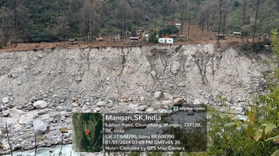
Source: Author, January 2024.
Routinely, each year, the movement of the livestock from the summer pasture to the winter pasture takes place in late October to early November. The timing of the GLOF was such that the livestock were all stuck in the summer pasture. Gyatso Lachenpa, the headman of the Dzumsa, remarked that “we were in the middle of discussing the date of the movement of the livestock; however, the GLOF caused an unprecedented delay in the finalisation of the dates due to the lack of connectivity and washing away of the lands”.[4]
Apart from difficulty with the livestock, agriculture was impacted, too. In terms of direct impact, numerous agricultural lands were washed away. Apart from grazing the animals, the winter pasture lands were also used for cultivation, though only for self-sustenance. However, the cultivation (particularly of potatoes) from the summer pasture lands, which is utilised for commercial purposes, could not reach the market due to the loss of connectivity. Hence, many farmers suffered losses as these potatoes rotted due to the lack of a cold storage facility.
Picture 4. Yak Conservation Area at Zeema Village with the washed-away land
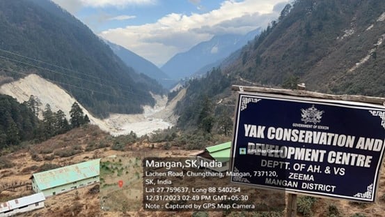
Source: Author, December 2023.
Community Resilience and Involvement in Reducing the Impact of the GLOF
The disruption to the movement of the livestock has gravely impacted the livelihood pattern of the community in question, especially for the individuals who depend on animal herding as their main source of income. For example, the herders depending on and herding their animals in the villages of Daray and Latong have been left with no pastoral lands now as these two villages have been washed away completely. As a result, their livestock is still stuck in the summer pastoral regions and could die with the winter snowfall. Ajo Kyapney[5], who for the past four decades, had kept his livestock at Daray Village, said that his farmhouse, connecting infrastructure and the pasturelands had been completely washed away and that he had no place to take his livestock during the winter months. Like him, numerous families face similar predicaments.
The local community’s participation and efforts at mitigating the damages caused by the GLOF have been particularly interesting. The role of Dzumsa, led by the Pipon (the headman of the Dzumsa), demonstrates an interesting instance of a community-led institution in mitigating the impact caused by the GLOF. Amongst the first institutions to reach out to the people was the Dzumsa. A particularly interesting point was how the Dzumsa were able to bring the community together and bring about a joint effort in terms of distributing relief items and providing food and shelter to the stranded tourists and labourers.
Picture 5. Log bridges constructed by the Dzumsa for the movement of livestock[6]
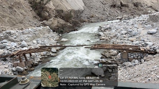
Source: Author, December 2023.
The Dzumsa played a particularly influential role in rebuilding lost connectivity. The transportation of skilled manpower and machinery became a massive problem as the area was completely cut off. This hampered the state’s role in improving connectivity as opening the roads and construction of the bridges was infeasible. The Dzumsa led the effort in building the connectivity. Many temporary wooden log bridges were built by the people, and even motorable roads, wherever possible, were constructed by the Dzumsa. These wooden log bridges and temporary roads came to aid during transhumance.
These practices of the Dzumsa depict the interconnection and synthesis of responsibilities, rights, and interests between the state and the local institutions, which are managed by the communities inhabiting the territory. It also shows the institutional solutions provided by these local communities in mitigating a crisis and establishing mechanisms to deal with the disaster. As the families presently involved in agro-pastoralism are members of the Dzumsa, and many other Dzumsa members have been agro-pastoralists in the past, it became easier for the Dzumsa as an institution to delineate these issues. State compensation, rehabilitation and report furbishing were actively processed with the help of the Dzumsa; as a result, the farmhouses and livestock loss were compensated accordingly. More than fifty families were compensated with monetary support.[7]
Conclusion
The livelihood pattern of the community in the upper riparian region of the Teesta River has been in a constant process of transformation. From the vibrant trading community before the 1960s, the community ventured into agro-pastoralism with the closure of the Sikkim-Tibet border. The region’s opening to the larger service sector (tourism industry) pushed many families to a new source of income away from animal rearing and agriculture. At the time of the GLOF last October, the general livelihood pattern of the region involved the service sector and the practice of agro-pastoralism.
The GLOF has affected both livelihood options. The tourism industry is down as the region is completely cut off. The impact on agro-pastoralism is severe and has potentially larger long-term ramifications. The prime grazing lands have been washed away along with the farmhouses. Further, firmer state laws regarding the freedom of livestock grazing, which comes with the majority of the lands being under the state, restrict the movement of these livestock. As such, a search for new pastures becomes impossible or infeasible. Such conundrums interpose further on the already dwindling agro-pastoral practices in the region. The nature of connectivity to the prime pastoral lands – either non-existent or in a bad state – has compelled the herders to herd the livestock along the highways. Such developments have disturbed the mobility of herds/livestock and access to the best pasture lands, impacting the nutrition of the animals.
At the same time, the GLOF and its aftermath also exhibit the crisis response mechanisms and institutional solutions of the local communities (Dzumsa). Regions at the periphery are usually where state institutions are either negligible or absent altogether. Under such circumstances local institutions can flourish and play a crucial role. The Dzumsa, over the years, has become the agency of the state in implementing many of its development policies on the one hand while it has also retained many autonomous characteristics on the other. These blurred lines were seen during the GLOF and the subsequent actions where the Dzumsa, in the absence of the state machinery, improved connectivity and managed the crisis.
References
Bhasin, Veena. 2012. ‘Social organisation, continuity and change: The case of the Bhutias of Lachen and Lachung of North Sikkim.’ J Biodiversity, Vol. 3, No. 1, 1-43.
Bourdet-Sabatier, Sophie translated by Anna Balickci-Denjongpa. 2013. ‘The Dzumsa of Lachen: An example of a Sikkimese political institution.’ Bulletin of Tibetology, 93-104.
Farooquee, Nehal A. 2010. ‘Changes in pastoralism in the Indian Himalaya.’ Cultural Survival, 26 March. https://www.culturalsurvival.org/publications/cultural-survival-quarterly/changes-pastoralism-indian-himalaya.
South Asia Network on Dams, Rivers and People. 2023. ‘Glacial Lake flood destroys Teesta-3 Dam in Sikkim brings wide-spread destruction’, 4 October. https://sandrp.in/2023/10/04/glacial-lake-flood-destroys-teesta-3-dam-in-sikkim-brings-wide-spread-destruction/.
Islam, Nazimul & Patel, Priyank Pravin. 2020. ‘Inventory and GLOF Hazard assessment of glacial lakes in the Sikkim Himalayas, India.’ Geocarto International, Vol. 37, No. 13, 3840-3876.
Krätli, S., & Schareika, N. 2010. ‘Living off uncertainty: The intelligent animal production of dryland pastoralists.’ The European Journal of Development Research, 22, 605-622.
Luxom, Nisam Mang et al. 2022. ‘Pastoral practices, pressures, and human-wildlife relations in high altitude rangelands of Eastern Himalaya: A case study of the dokpa pastoralists of North Sikkim.’ Pastoralism: Research, Policy and Practice, Vol. 12, No. 37, 1-19.
Robinson, L., & Flintan, F. 2022. ‘Can formalisation of pastoral land tenure overcome its paradoxes? Reflections from East Africa.’ Pastoralism, Vol. 12, No. 1, 34.
Rota, A., Krätli, S., Nori, M., Bellinguez, A., Bassi, M., & Oliver Mundy. 2018. How to do note: Engaging with pastoralists—A holistic development approach. Rome: IFAD.
Silvestri, S., P. Osano, J. de Leeuw, M. Herrero, P. Ericksen, J. Kariuki, J. Njuki, C. Bedelian, & A. Notenbaert. 2012. Greening livestock: Assessing the potential of payment for environmental services in livestock inclusive agricultural production systems in developing countries. Nairobi: International Livestock Research Institute (ILRI).
Thapa, Sandhya and Sachdeva & Swati A. 2017. ‘Institution of Dzumsa in North Sikkim: A Sociological Understanding.’ Sociological Bulletin, Vol. 66, No. 2, 212-222.
Turner, M. D., McPeak, J. G., Gillin, K., Kitchell, E., & Kimambo, N. 2016. ‘Reconciling flexibility and tenure security for pastoral resources: The geography of transhumance networks in eastern Senegal.’ Human Ecology, Vol. 44, No. 2, 199-215.
[1] The 73rd Amendment Act, 1992 of the Indian Constitution established the Panchayati Raj Institutions in India. Tantamount with the 73rd Amendment Act, Sikkim passed the Sikkim Panchayat Act in 1993 which established a two-tier Panchayat Raj Institution system at the village and district level. The Act Amended in 2001, delineates on the Dzumsa and posits that the Dzumsa system prevalent in the two valleys of Lachen and Lachung in the North Districts of Sikkim shall continue to exist in accordance with the traditional and customary laws of the Dzumsa.
[2] Author’s field notes, 2023.
[3] Author’s field notes, 2023.
[4] Personal communication to the Author, 25 December 2023.
[5] Ajo Kyapney is one of the oldest surviving individuals in the village of Lachen. Personal communication to the author, 24 December 2023.
[6] Under infrastructure development projects in the region, mainly under the Border Area Development Programme (BADP), many permanent cement bridges were constructed and has led to less need for constructing log bridges.
[7] Author’s field notes, 2023.
About the Author: Dr. Sangay Lachenpa is a Guest Faculty at Department of International Relations, Sikkim University’. He can be reached at [email protected].