
Beyond the Military Prism: China’s Development Objectives in Xiaokang Villages in Tibet Autonomous Region
Abstract
In 2017, China unveiled a policy to develop more than 600 bianjing xiaokang cun, or ‘moderately well-off border villages’, in 21 border counties in the Tibet Autonomous Region. This study examines how the policy is being implemented in 44 villages in four border counties in Ngari prefecture and in Droma county in Shigatse City using qualitative data about development policies, political activities, and geographical locations of the villages. While acknowledging the strategic significance of these villages for China’s military objectives, including territorial claim-making, the study urges scholars and policymakers to pay attention to broader and longer-term objectives of the policy, such as populating border areas, Party-building, and achieving political and administrative control at the grassroots. Further, we argue that the policy has important implications for understanding how the Chinese state funds and implements development policies in its vast borderlands.
Keywords: Tibet Autonomous Region (TAR), xiaokang villages, dual-use infrastructure, economic development, poverty alleviation, Tibet policy, India-China relations.
China has built 628 bianjing xiaokang cun (边境小康村) or ‘moderately well-off border villages’ since 2017 when the policy was first unveiled in the border counties of Tibet Autonomous Region (TAR) (Renmin Ribao 2018). The Chinese construction has generated considerable debate among policymakers, scholars, and in the media about the nature of these villages and China’s military strategy vis-à-vis India. The dominant thinking is that villages are for ‘dual use’, meaning their use involves both civilian and military purposes (Nithiyanandam 2024; Jun Hart 2024; Kumar, A. 2024). Further, they are also considered part of China’s salami-slicing tactics to solidify spurious claims over the territory of neighbouring countries or as bargaining chips at boundary negotiations as in the case of Bhutan (Barnett 2021; Shekhawat 2022; see also, Nithiyanandam 2024; Kumar, A. 2024). The creation of this infrastructure by China and the possibility they might be used for military purposes drive a sense of anxiety in India over China’s plans for future military actions along the Line of Actual Control (LAC), and is seen as proof by outside observers of yet another case of China’s hegemonic behaviour in its neighbourhood (Xiao and Chang 2024).
This study acknowledges and addresses the military objectives of China’s policy of building xiaokang villages in border counties in the TAR but it furthers the discussion and analysis by arguing that domestic socio-economic and political goals in these villages are equally important to the Chinese state. These include rural revitalization, increasing the population of border areas, and commercialization of agro-pastoral products on the one hand and ensuring stronger control of the ruling Communist Party of China (CPC) regime over the Tibetan population on the other (Xizang Zizhiqu Nongye Nongcunting 2024; Xizang Xinwen Wang 2021). Xiaokang villages across the Eastern Sector of the India-China boundary dispute are relatively well covered in the literature (Nithiyanandam 2024). This study, therefore, examines Chinese government policies in xiaokang villages in four counties of Ngari prefecture (Ali diqu, 阿里地区) in western TAR and in Droma county (Yadong xian, 亚东县) in Shigatse city (Xigaze/Rikaze shi, 日喀则市) in southern TAR to highlight the socio-economic and political goals and to place military objectives in perspective.
Of the 628 villages planned to be built over a three-year period in the first phase, 427 were designated first-line border villages and 201 as second-line villages. An unspecified number of villages is being built in the second phase of the programme that started in 2020. However, only 604 villages were completed in the first phase ending in 2020 with another 20 being completed by 2022 (Xinhua 2020; Xinhua 2022).
The 44 xiaokang villages examined in this study are located in Ruthog, Tsamda, Gar and Purang counties in Ngari prefecture and in Droma county in Shigatse city (Figure 1). All but one are first-phase villages and each village is identified based on information from official sources on its designation as a xiaokang village. After identifying the list of villages, they were located using Google Earth and their distances from the Line of Actual Control (LAC) or the international boundary with India (IB) or Bhutan measured. We gathered qualitative data about these villages from official sources at the county, prefecture, and provincial levels, media reports from Xizang Ribao (Tibet Daily, 西藏日报), Xinhua, Sina.com, Sohu, and social media posts (on QQ, Weixin, Bilibili, and Douyin) to understand the nature of socio-economic life, government policies, and Party activities being carried out.
Figure 1
County-level Map of Tibet Autonomous Region
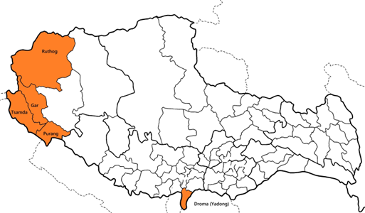
Source: Modified by authors from original map by the Amnye Machen Institute, Dharamshala, Himachal Pradesh (http://www.tibetmap.com/TARbr.html).
The remainder of the essay is divided into three parts. The first provides a brief overview of the origins of the policy on xiaokang villages with a reference to the critical role played by the Tibet Aid Program in its implementation; the second examines China’s domestic objectives including those of Party-building and ensuring stronger Party control in the restive minority province; the third section looks at the location of xiaokang villages in the counties being studied and draws some inferences from a military perspective. The concluding section offers a discussion of the implications of bianjing xiaokang cun (moderately well-off border villages) beyond the dominant military prism. The paper argues that military objectives and economic development objectives are linked together by the Chinese Party-state’s larger and long-standing concerns over regime legitimacy and internal consolidation.
The remainder of the essay is divided into three parts. The first provides a brief overview of the origins of the policy on xiaokang villages with a reference to the critical role played by the Tibet Aid Program in its implementation; the second examines China’s domestic objectives including those of Party-building and ensuring stronger Party control in the restive minority province; the third section looks at the location of xiaokang villages in the counties being studied and draws some inferences from a military perspective. The concluding section offers a discussion of the implications of bianjing xiaokang cun (moderately well-off border villages) beyond the dominant military prism. The paper argues that military objectives and economic development objectives are linked together by the Chinese Party-state’s larger and long-standing concerns over regime legitimacy and internal consolidation.
Origins and Methods
The origins of the current plan for xiaokang villages, at least ideationally, can be traced back to CPC General Secretary Xi Jinping’s speech at the 6th Tibet Work Forum in 2015 when he argued that “to govern the country, we must govern the border areas, to govern the border areas, we must stabilize Tibet” (zhiguo bi zhibian, zhibian xian wen Zang, 治国必治边,治边先稳藏) (Xinhua 2015). While there is lack of contextual information to trace policymaking and decision-making processes, publicly available documents, however, indicate the origins of the idea can be traced back to the early 2000s. The idea got initial traction in the annual Central Rural Work Conference (Zhongyang Nongcun Gongzuohui, 中央农村工作会) of the 16th Central Committee in 2003, where then CPC General Secretary Hu Jintao gave a positive assessment of the concept proposed by the rural and urban development research department of the Chengdu Mountain Institute (Chengdu Shandisuo, 成都山地所), a research institute of the Chinese Academy of Sciences, that aimed to solve the “three rural problems” (san nong wenti, 三农问题) – low agricultural productivity, low peasant income, and undeveloped rural infrastructure – in Tibetan areas (Zhongguo Kexueyuan 2004). According to media reports of the time, the TAR provincial government had entrusted the Institute with designing a plan for developing xiaokang villages in 12 areas in nine counties in TAR. It is important to note that a specific focus on border counties was still missing in these discussions. In 2016, once again, the TAR provincial government tasked the same institution to give recommendations for initiatives while taking cues from Xi’s direction for development of border areas (Guojia Shengtai Kexue Shuju Zhongxin 2019).
As such, therefore, the policy has a longer genealogy than generally attributed in leader-centric official discourses in the CPC’s thinking on borders and border governance. Considered over the long-term, the development of xioakang villages and the assertion that defending the border is key to better governance and stability is the latest phase of shifts in policies and discourses on these issues. The current policy in the Xi era builds on the post-Mao policy focus on stability and security through development by adding stress on enforcing ethnic unity and ensuring significantly greater resources devoted to these tasks (Luo and Deng 2024). It must be further underlined that these policies are not limited to TAR but apply to all of China’s vast borderlands (Leibold 2024b; see also, Allen, Impiombato and Attrill 2024).
Nevertheless, it is difficult to identify why it took more than a decade for the national and provincial leadership to undertake the initial plan even though politically powerful agencies such as the National Development and Reform Commission and top leaders like Hu had voiced support for the initiative. The gradual, protracted process of unveiling the plan for developing xiaokang villages in TAR has implications for our understanding of Chinese policymaking and implementation – it should help debunk narratives of the Chinese political system’s efficiency in planning and executing developmental projects at great speed. It is time for scholars to examine these difficulties to better understand China’s policies in border areas.
Meanwhile, for the purposes of this essay, suffice it to say that the plan for xiaokang villages originated in debates over managing rural problems, a severe socio-political challenge discussed since the early 2000s in China, and that it has taken a long time to implement. This implementation has depended on a combination of policy instruments including, critically, the long-running Tibet Aid Program.
Started in its current form in 1994 after the Third Tibet Work Forum, the Tibet Aid Program has been ramped up massively in Xi Jinping’s tenure (for more see, Kumar, D. 2024b; Leibold 2024a). Under the Program, partner provinces, cities or central agencies and institutions extend support to localities in TAR they have been paired with in several policy areas such as poverty alleviation, and medical and education assistance.
Take for example, Tsamda County in Ngari, which was one of the poorest counties in TAR before poverty alleviation goals were said to have been achieved in 2020 for the whole country. In this border county, several xiaokang villages exist including Tsaparang (Zhaburang cun, 扎布让村) (see Table 1) supported by Hebei province under the Tibet Aid Program with a particular focus on poverty alleviation and “group style” (zutuan shi, 组团式) medical and education assistance (Sohu.com 2020). As is the case with other parts of TAR, poverty alleviation has involved large-scale relocation of people to small towns and settlements from nomadic and temporary settlements. However, villages like Tsaparang, one of the earliest ones in Tholing town, are not entirely new settlements but rejuvenated villages with investments in new social and physical infrastructure and relocation of farmers and herders (QQ.com 2024). In another example involving Tibet Aid Program actors – Pangda village (庞达村) in the Chumbi Valley – state-owned steel companies like Baowu Steel from Shanghai provided prefabricated steel houses (Baowu Group 2020).
Note should be taken also of the uneven implementation of policies in xiaokang villages. Chinese official narratives often highlight ‘demonstration villages’ (shifan cun, 示范村) to showcase successful implementation of the policy. It is these villages that Chinese officials are usually shown as visiting. The fact, however, is that not all xiaokang villages receive the same facilities or degree of attention owing to the usual difficulties of terrain and distance among other factors.
Domestic Objectives
China’s Tibet policy in Xi Jinping’s ‘new era’ (zhi Zang fanglüe, 治藏方略) broadly consists of four goals – stability, development, ecology, and strengthening the border – that are often emphasized from local to national levels as the “four events” (sijian dashi, 四件大事). That Xi “attaches great importance, always cares about, has feelings for Tibet, and personally steers the direction of Tibet work” (gaodu zhongshi Xizang gongzuo, shizhong xinxi Xizang, qingsi Xizang, qinzi wei Xizang gongzuo ba duo dingxiang, 高度重视西藏工作,始终心系西藏、情系西藏,亲自为西藏工作把舵定向) has often been stressed by officials and the Party-state apparatus (see Qiushi 2022). This underlines the strong central government backing for the policy of xiaokang villages.
At the same time, it also needs to be underlined that despite the centrality of stabilizing Tibet in Xi’s nationalist agenda, the nitty gritty of policy implementation is unlikely to be supervised at the micro level by either him or his immediate policy circle. In its current form, the policy of building xiaokang villages was a provincial level initiative through the ‘TAR border areas xiaokang villages building plan (2017-2020)’ (Xizang Zizhiqu bianjiang diqu xiaokang jianshe jihua, 西藏自治区边境地区小康村建设规划 (2017-2020)) in response to Xi’s exhortation in 2015 that border defence was essential for national security (Huanqiu Ribao 2020).
Building small-scale infrastructure like schools, mobile towers, and roads, and building grassroot organizations such as CPC committees at the village level, and the establishment of cooperatives, together form part of a policy being pursued in the region since 2009 with the aim of facilitating an increase in the population of border areas and permanent settlement of nomads. In this context, the government has pushed to relocate farmers and herders to these villages both from nearby places as well as from faraway locations. Under this policy beginning in 2016, the government has aimed to relocate more than half a million people from what it considers ecologically sensitive areas such as Qiangtang (羌塘) in several counties in Nagchu in northern TAR to Lhasa, the capital, and to border prefectures such as Nyingchi and Lhoka in southwestern TAR bordering Arunachal Pradesh (Yao Shuang 2022; Nyima and Yeh 2023; Human Rights Watch 2024). Several villages including Pangda in Bhutanese-claimed territory and Ngari have populations relocated from nearby places.
Meanwhile, xiaokang villages have also been the targets of Party-building activities with a broader focus on grassroots governance. These initiatives aim at developing grassroots Party organizations in villages as “battle fortresses” (zhandou baolei, 战斗堡垒), which include a range of activities such as cultural activities to propagate the Party’s ideology and policies, establishing village Party committees, and recruiting new members, among others (Zhongguo Gongchandang Xinwenwang 2019; Qiushi 2020; Yunnan Chang’an Wang 2023). Media reports show that xiaokang villages along the LAC are also targets of these initiatives. In addition to Party bodies such as village branches, under a programme started in 2011, the Party authorities send work teams from higher levels to villages (zhucun gongzuodui, 驻村工作队) across the region. Thousands of cadres have served in villages for short terms since then, including in xiaokang villages, helping build grassroots institutions and spreading the Party’s messages (Xizang Xinwen Wang 2017).
Creating farmers’ and herders’ cooperatives is a region-wide policy which is also key to implementing the policy of xiaokang villages. Such cooperatives serve multiple purposes including the Party-state’s greater control over mobile populations in border areas, spurring commercialisation of agro-pastoral products to create local sources of income, and populating remote areas (Zhongguo Gongchangdang Xizangzizhiqu Weiyuanhui 2020; Wang and Ning 2019) including some villages in territories claimed by other countries, such as the Pangda village in Bhutan. Commercialization has been spurred by the Tibet Aid Program to better economically and commercially integrate TAR’s economy into China’s domestic and foreign supply chains (Ye and Yu 2024) – as Table 1 shows, most villages have such cooperatives as the main source of income for the relocated population (Sina.com 2022). Since 2009, these cooperatives have helped authorities to have a greater control of society through a widely used model of “party base + cooperative society + farmer” (dangzhibu + hezuoshi + nonghu, 党支部+合作社+农户) governing these cooperatives (Xizang Xinwen Wang 2021).
Location
Strong borders in terms of better infrastructure, connectivity, and reliable sources of livelihood for the local population help further political and social stability and thus also aid military other strategic goals.
This study uses the metric of distance from the LAC or the international boundary (IB) with either India or Bhutan – as calculated from Google Earth – to differentiate between xiaokang villages and to provide some perspective to the issue of their dual use. Villages located within approximately 50 kms as the crow flies from the nearest point on the LAC or international boundary are defined as being close to the LAC with the implication that they can be of potential military use such as for territorial claim-making, for tactical support for military operations, as well as for day-to-day support for security forces guarding the border.
Table 1
Distribution of Border Xiaokang Villages in Ngari Prefecture and Droma in Shigatse City
|
County |
Village |
Town/Township |
Approximate distance from LAC/IB/Bhutan border (in kms)
|
Key Features |
|
Tsamda (札达县,རྩ་མདའ་རྫོང) 13 villages |
Tsaparang (扎布让小康村, རྩ་བྲང) |
Tholing (托林镇,མཐོ་ལྡིང)
|
45 kms [31°28’01”N 79°40’17”E]
|
|
|
|
Baka (巴卡村) |
Tsosib Sumkyil Township (楚鲁松杰乡, ཚོ་སྲིབ་གསུམ་དཀྱིལ)
|
83 kms 31°12'51"N 80°53'55"E |
|
|
|
Tsosib (楚松村) |
Tsosib Sumkyil Township (楚鲁松杰乡, ཚོ་སྲིབ་གསུམ་དཀྱིལ)
|
4.5 kms [32°06'34"N 78°42'36"E] |
|
|
|
Bolin (波林小康村) |
Tholing (托林镇,མཐོ་ལྡིང)
|
15 kms [31°20'20"N 79°25'39"E]
|
|
|
|
Rebujialin (热布加林村) |
Qangzê Township (香孜乡,བྱང་རྩེ་ཤང་།)
|
65 kms [31°55’47”N 79°32’41”E]
|
|
|
|
(什布奇村) |
Diyag Township (底雅乡,ཏི་ཡག་ཤང་།)
|
2.5 kms [31°48’41”N 78°44’42”E]
|
|
|
|
Dongbo (东波村,མདོང་པོ) |
Daba Township (达巴乡,མདའ་པ) |
30 kms [31°07’08”N 80°07’19”E]
|
|
|
|
Kyunglung (曲龙村,ཁྱུང་ལུང) |
Daba Township (达巴乡,མདའ་པ) |
50 kms [31°04'18"N 80°33'27"E]
|
|
|
|
Qumudi (曲木底村) |
Qusum Township (曲松乡,ཆུ་གསུམ་ཤང་།) |
25 kms [32°12’01”N 79°11’04”E]
|
|
|
|
Kazibolin (卡孜村,མཁར་རྩེ་) |
Qangzê Township (香孜乡,བྱང་རྩེ་ཤང་།)
|
65 kms [31°49’54”N 79°37’34”E]
|
|
|
|
Luba (鲁巴村) |
Diyag Township (底雅乡,ཏི་ཡག་ཤང་།)
|
35 kms [31°43’30”N 79°15’00”E]
|
|
|
|
Riba (日巴村) |
Dzarong Township (萨让乡,རྫ་རོང་ཤང་།) |
18 kms [31°36’56”N 79°06’56”E]
|
|
|
|
Sarang (萨让村,ཟ་ཧྲེང)
|
Dzarong Township (萨让乡,རྫ་རོང་ཤང་།) |
15 kms [31°33'57"N 79°03'04"E]
|
|
|
Ruthog (日土镇, རུ་ཐོག་གྲོང་རྡལ།) 8 villages |
Domar (多玛村, རྡོ་དམར་ཤང་།) |
Domar Township (多玛乡, རྡོ་དམར་ཤང་།)
|
95 kms [33°42’25”N 80°22’33”E]
|
|
|
|
Wujiang (乌江村) |
Domar Township (多玛乡, རྡོ་དམར་ཤང་།)
|
70 kms [33°37’04”N 79°48’43”E]
|
|
|
|
Derub (德汝村, སྡེ་རུབ also called Kugtang, 库让, ཁུག་ཐང)
|
Risum Township (日松乡, རི་གསུམ་ཤང་།)
|
27 kms [33°22’15”N 79°41’48”E]
|
|
|
|
Guoba (过巴村) |
Risum Township (日松乡, རི་གསུམ་ཤང་།) |
60 kms [33°07’03”N 80°03’32”E]
|
• poverty alleviation site with focus on creating employment through gravel collection plant |
|
|
Rejiao (热角村) |
Ruthog Town (日土镇,རུ་ཐོག་གྲོང་རྡལ།)
|
15 kms [33°24’31”N 79°11’50”E]
|
ecological landscape corridor |
|
|
Longmenka (龙门卡村) |
Rabang Township ((热帮乡, ར་སྤང་ཤང་།)
|
85 kms [33°05’08”N 80°22’09”E]
|
|
|
|
Ruthog (日土村, རུ་ཐོག་གྲོང་) |
Ruthog Town (日土镇,རུ་ཐོག་གྲོང་རྡལ།)
|
25 kms [33°24’57”N 79°38’37”E]
|
|
|
|
Chakgang (甲岗村, ལྕགས་སྒང) |
Risum Township (日松乡, རི་གསུམ་ཤང་།)
|
27 kms [32°52’25”N 79°50’32”E]
|
|
|
Gar / Senge Tsangpo (噶尔县, སྒར་རྫོང་།) 6 villages
|
Gar Chongsar (噶尔新村, སྒར་གྲོང་གསར) |
Günsa Township (昆莎乡, དགུན་ས)
|
75 kms [32°06’37”N 80°03’14”E] |
|
|
|
Jiamu (加木村) |
Senggekanbab Town (狮泉河镇, སེང་གེ་ཁ་འབབ) |
60 kms 32°27'45"N 80°09'38"E |
|
|
|
Ruma (鲁玛村) |
Tashigang Township (扎西岗乡, བཀྲ་ཤིས་སྒང)
|
65 kms 32°13'00"N 80°02'00"E Google Earth |
|
|
|
Tashigang (扎西岗村) |
Tashigang Township (扎西岗乡, བཀྲ་ཤིས་སྒང)
|
20 kms 32°30'37"N 79°41'33"E |
|
|
|
(典角村, བདེ་མཆོག) |
Tashigang Township (扎西岗乡, བཀྲ་ཤིས་སྒང) |
Group 1 17 kms [32°35’22”N 79°35’02”E]
Group 2 1 km [32°41’44”N 79°27’32”E]
|
|
|
|
Xiazuozuo (下左左村) |
Zoco Township (左左乡, གཙོ་ཚོ་ཤང་།, also called Goicang རྒོད་ཚང་)
|
125 kms [32°16’24”N 80°49’11”E]
|
|
|
Burang (普兰, སྤུ་ཧྲེང་རྫོང) 7 villages |
Bangren (帮仁村)
|
Hor/Huo’er Township (霍尔乡, ཧོར་ཤང) |
80 kms [30°46’25”N 81°37’06”E]
|
|
|
|
Xiongba / Xungba Chongco (雄巴村, གཞུང་པ་གྲོང་ཚོ།)
|
Parga Township (巴嘎乡, བར་ག་ཤང༌།) |
65 kms [30°45’55”N 81°21’47”E]
|
|
|
|
Rengong / Dongmar (仁贡村, གདོང་དམར) |
Burang Township (普兰镇, སྤུ་ཧྲེང་རྫོང) |
25 kms [30°27’20”N 81°06’58”E]
|
|
|
|
Gangsha / Kangsa Chongco (岗莎村, གངས་ས་གྲོང་ཚོ།) |
Parga Township (巴嘎乡, བར་ག་ཤང༌།) |
85 kms [30°58’31”N 81°17’08”E]
|
|
|
|
Kejia (科迦村, འཁོར་ཞགས་ད) |
Burang Township (普兰镇, སྤུ་ཧྲེང་རྫོང) |
21 kms [30°11’45”N 81°16’09”E]
|
|
|
|
Chide (赤德村, ཁྲི་སྡེ) |
Burang Township (普兰镇, སྤུ་ཧྲེང་རྫོང) |
15 kms [30°17’31”N 81°10’26”E]
|
|
|
|
Xide (细德村, གཞི་སྡེ) |
Burang Township (普兰镇, སྤུ་ཧྲེང་རྫོང) |
13 kms [30°14’45”N 81°10’53”E]
|
|
|
Droma (Yadong) (亚东县, གྲོ་མོ་རྫོང) 10 villages
|
Pangda (庞达村) |
Dromomey Township (下亚东乡, གྲོ་མོ་སྨད་ཤང་།) |
inside the Jigme Khesar Nature Reserve in Bhutan Group 1 [27°18’24”N 89°00’27”E]
Group 2 [27°19’16”N 89°00’24”E]
|
|
|
|
Renqinggang (仁青岗村, རིན་ཆེན་སྒང)
|
Dromomey Township (下亚东乡, གྲོ་མོ་སྨད་ཤང་།) |
8 kms (Bhutan) [27°26’01” N 88°54’03” E]
|
|
|
|
Duina (堆纳村, དུད་སྣ) |
Duina Township/ Duna (堆纳乡, དུད་སྣ)
|
18 kms (Bhutan) [27°58’47”N 89°13’57”E]
|
|
|
|
Asang (阿桑村, ཨ་སམ)
|
Dromomey Township (下亚东乡, གྲོ་མོ་སྨད་ཤང་།) |
1 km (Bhutan) [27°24’28”N 88°57’32”E]
|
|
|
|
Guru (古汝村, རྒུར་རུ) |
Tuna Township (堆纳乡, དུད་སྣ་ཤང་།) |
20 kms (Bhutan) [28°05’41”N 89°16’36”E]
|
|
|
|
Sangang New Village (三岗新村) (Rubinggang, 汝丙岗村) |
Dromotod Township (上亚东乡, གྲོ་མོ་སྟོད་ཤང་།) |
2.5 kms (Bhutan) [27°30'59"N 88°58'13"E]
|
‘Red tourism’ (related to PLA/Party history) site (Zhang Jingwu Memorial Hall, 张经武纪念馆)
|
|
|
Chema / Phyemar (切玛村, ཕྱེ་མར་) |
Dromomey Township (下亚东乡, གྲོ་མོ་སྨད་ཤང་།) |
5 kms (Bhutan) [27°26’39”N 88°55’21”E]
|
|
|
|
Tangbu (唐布村, ཐང་བུ) |
Tuna Township (堆纳乡, དུད་སྣ་ཤང་།) |
7 kms (Bhutan) 28°03'49"N 89°24'09"E
|
|
|
|
Shang Kangbu (上康布村, གམ་བུ)
|
Kangbu Township (康布乡, ཁམ་བུ་) |
13 kms (IB) 27°46'30"N 88°59'32"E
|
|
|
|
Chunpi (春丕村, ཆུ་འབི)
|
Xia Sima Town (下司马镇, ཤར་གསིང་མ) |
7 kms (Bhutan) [27°29’18”N 88°54’22”E]
|
|
Sources: Compiled by the authors.
Note: Of the 37 xiaokang villages known to exist in Ngari (Zhongguo Zhongyang Dianshitai 2022), this study only looks at 34 – three could not be identified either by name or location.
Note on names of places: The table uses the following format for names of places: Roman version of Tibetan name, name in Chinese, and name in Tibetan. Wherever the names of places are not available in Tibetan or English, names have been transliterated using the pinyin system.
By the benchmark of distance, 14 out 44 villages – approximately one-third – are not close to the LAC. But this figure has to be qualified. The difference between xiaokang villages in Ngari prefecture in the western part of TAR and those in Droma in southern TAR is significant. In the case of the former, out of a total of 34 xiaokang villages identified, just over half (20) are close to the LAC, while in the case of the latter, out of ten villages identified in the Droma county, nine are located near the international boundary while one (Pangda) is inside Bhutanese territory – thus, relatively fewer villages can, serve as tactically-useful platforms for military operations in Ngari. This can suggest several things – that terrain difficulties in Ngari are not as difficult as in Droma for xiaokang villages to be sited so close to the LAC, that for the moment at least, security objectives and territorial claim considerations are much more serious with respect to Droma than they are in Ngari, or both.
In fact, the location of xiaokang villages is determined by contingent factors such as geography, economic conditions, and other policy factors. Not all villages are newly-built; most have been “revitalized” (zhenxing, 振兴) through relocation of farmers and herders – a region-wide policy creating farmers’ and herders’ cooperatives, and funded by a mix of policy tools including subsidies to residents and the Tibet Aid Program. Villages like Demchok Village (see Table 1), for example – near areas involved in Sino-Indian tensions, including the latest round in 2020 – are older settlements being redeveloped (Xizang Zizhiqu Nongye Nongcunting 2019). Meanwhile, Sangang New Village (Sangang Xincun, 三岗新村) – part of the second phase of xiaokang villages (2020-2025) – was established at a new location and housed earthquake-affected people by merging three villages (Ganglingan, 嘎林岗, Runaigan, 如丙岗, and Ganggu, 岗固) in 2011. Similarly, xiaokang villages in the area of the former Guge Kingdom and near Kailash Mansarovar Lake were selected due to their importance for tourism. Considering these local factors and the bureaucratic processes to select villages for development under the programme is critical in understanding larger implications and differentiating multiple goals.
The geographical location and socio-economic infrastructure of these villages are part of broader policy objectives such as repopulating border areas, settling nomadic populations, and spurring local sources of income and economic growth through tourism and revitalization of animal-husbandry and handicraft industry. The construction of infrastructure in the villages also provides a source of employment for local Tibetans. Thus, the revitalization of these villages contributes to national security in a strategic rather than a limited tactical sense. This said, some problems that these policies were aimed at addressing, continue. Tibetans continue to escape (although in much lesser numbers than in the past) and precious commodities such as gold are smuggled across the border in Droma (Namgay 2018), most likely with the tacit complicity of Chinese border security forces, underlining a degree of porosity of borders evading the Chinese state’s efforts at increased securitization.
Of more immediate concern to India and Bhutan should be the newly-established border xiaokang villages. In our study, new villages are few in number but crucial as they are located very close to the LAC and near or within Bhutanese territory. These villages are built to make territorial claims by ‘establishing facts on the ground’. There is also evidence that apart from Pangda village, China has started settling nomadic populations in northern Bhutan (Barnett 2021). These settlements have not yet been designated as xiaokang villages but serve the same purpose and might be designated so in China’s 15th Five Year Plan (2025-2030).
Settling population in or near the LAC has obvious implications for the India-China boundary dispute. Article VII of the Agreement on Political Parameters and Guiding Principles for the Settlement of the India-China Boundary Question signed between India and China in 2005 states that the two countries “shall safeguard due interests of their settled populations in the border areas” while demarcating the boundary (Ministry of External Affairs 2005). Therefore, the objective of the Chinese policy to increase the population of border counties, principally through settling nomadic populations in new settlements, especially in occupied areas in the Western Sector of the boundary dispute, is an attempt to exploit this clause even if these xiaokang villages might not support the People’s Liberation Army tactically.
In a highly securitised discourse, China’s policy of xiaokang villages can be easily (mis)interpreted as being part of a military strategy. However, we argue that despite its implications for military operations, the slow and non-military institutional origins of the policy, and its focus on socio-economic development as well as territorial claim-making should be acknowledged. This is not to say that China cannot or will not develop xiaokang villages to serve larger military goals, but the nuanced perspective employed here allows us to study equally consequential matters such as China’s approaches to borderland governance and how China funds and might sustain dual-use infrastructure in border areas.
Conclusion
Border defense has been a key objective during Xi Jinping’s tenure and developing border xiaokang villages is one of several policies towards this end. And yet, it is not simply territorial objectives against India or Bhutan that are at stake here for Beijing for if it were, China could have simply built purely military stations at possibly lower costs and with lower effort instead of xiaokang villages. But as this study makes clear, there are several more objectives of xiaokang villages besides their functions supporting Chinese military objectives.
The Chinese Party-state’s efforts are also about achieving efficient administration and political stability in TAR. Its policies aim to penetrate deeper into local society through village-based cadre teams, Party-building at the village level, mass activities for ideological and legal consciousness and, in the xiaokang villages, also the establishment of farmers’ and herders’ cooperatives.
China’s socio-economic plans in xiaokang villages and the implementing agencies involved highlight a larger development policy objective that analysts and observers should be aware of. It should be noted, for example, that xiaokang villages exist also in Yunnan province with similar goals (Zhonghua Renmin Gongheguo Nongye Nongcunbu 2021). Many villages in TAR are sites of relocation as part of poverty alleviation and rural revitalization programmes with one focus being on tourism around the Kailash Yatra and the ancient Guge Kingdom.
With its strategy of Economic and Technology Development Zones in TAR that aim to develop the Tibetan economy away from traditional sectors and toward export-oriented industries, construction, and even high-tech manufacturing (Kumar, D. 2024a), it is quite possible that xiaokang villages will become part of this approach. This can lead to a greater interest in TAR for economic exchanges across the LAC/international boundary. While economic development can potentially address livelihood concerns of Tibetans as well as mitigate their political concerns, the possibility that such development will bring with them further domestic social and political challenges – for example, a rise in Tibetan disaffection due to Han inward migration and discrimination in favour of the latter – cannot be ruled out either. Add to these also diplomatic challenges over the boundary dispute with India.
Taken together, the Chinese-Party state’s policies with respect to xiaokang villages reflect anxieties about territorial and political control over minority-dominated border areas. Attempts to improve socio-economic conditions in border areas by settling nomadic populations in xiaokang villages serves multiple purposes. For one, it aids the narrative of the Chinese state as a modernizing influence and a welfare state in comparison to both Tibet’s perceived past as a feudal society as well as conditions in border areas in the countries bordering Tibet – India, Nepal and Bhutan – where populations can often be cut off from the mainstream and possess low development indicators. For another, the settlement of populations can serve the function of better central administration, including surveillance, by breaking access to traditional patterns of movement or migration, and ties to the land. Making it even more difficult for Tibetans to flee their homeland into exile is certainly one objective.
China’s xiaokang villages are, thus, simply the latest method in a long historical process of state construction and territorial consolidation in its peripheries. And more than ever before, the Chinese state has the means – administrative, economic, military, and technological – to corral nomadic populations into fixed settlements more amenable to both economic production and centralised control while also serving border security and territorial claim-making purposes.
Endnotes
[i] The villages are categorized into first and second line xiaokang villages for the purposes of assigning subsidies and other state support to villages. The residents in the first line (第一钱) villages get higher subsidies and support than the second line (第二钱) villages. Officials and cadres in the former also get higher salaries and benefits (Xizang Zizhiqu Renmin Zhengfu 2023).
[ii] This works uses Tibetan names as far as possible as listed in maps by the Amnye Machen Institute Dharamshala, Himachal Pradesh available at http://www.tibetmap.com/TARbr.html. If there is a better-known Chinese name, this is mentioned in brackets. Wherever Tibetan names were unavailable, the Chinese name available was used.
[iii] It should be noted that Ngari Prefecture and Droma in Shigatse fall under the jurisdiction of two separate military districts of China’s Western Theatre Command. The former comes under the Xinjiang Military District while the latter is under the Tibet Military District (Wei 2015; Guo 2019).
REFERENCES
Allen, Bethany, Daria Impiombato and Nathan Attrill. 2024. ‘“Northern frontier culture”: How China is erasing “Mongolia” from Mongolian culture.’ Australian Strategic Policy Institute. 29 August. https://www.aspistrategist.org.au/northern-frontier-culture-how-china-is-erasing-mongolia-from-mongolian-culture/.
Baowu Group. 2020. ‘Xizang bianjiang Pangda cun Zangmin xingfu manman: “zhe shi women de xiangwang de jia”‘ (西藏边境庞达村藏民幸福满满: “这是我们向往的家!”) [ Tibetans in Pangda Village on the border of Tibet are full of happiness: “This is the home we long for!”]. 14 October. https://www.baowugroup.com/media_center/news_detail/202046.
Barnett, Robert. 2021. ‘China Is Building Entire Villages in Another Country’s Territory.’ Foreign Policy. 7 May. https://foreignpolicy.com/2021/05/07/china-bhutan-border-villages-security-forces/.
Guojia Shengtai Kexue Shuju Zhongxin (国家生态科学数据中心) [National Science and Technology Infrastructure]. 2019. ‘Guanyu Xizang zhizhiqu bianjing diqu xiaokang shifan cun jianshe guihua’ (关于 西藏自治区边境地区小康示范村建设规划) (2017-2020) [The Construction Plan for well-off demonstration villages in border areas of Tibet Autonomous Region 2017-2020]. 27 February. https://www.cnern.org.cn/content.jsp?id=40424.
Guo Jiahao. 2018. ‘Gong jun she xibu zhanqu zhi zhanlue kailiang yu renwu yanjiu’ (共軍劃設西部戰區之戰略考量與任務研究) [A Study on the Strategic Considerations and Tasks of the Establishment of the PLA Western Theater Command]. Unpublished PhD Thesis. National Defense University, Taiwan. 8 May. https://www.fhk.ndu.edu.tw/uploads/15458105208557lbWWW5o.pdf.
Huanqiu Ribao (环球日报) [Global Times]. 2020. ‘Zuo Shensheng guotu shouhuzhe, Xinfu jiayuan jianshezhe, zai Xizang bianjing xiaokangcun kan gubian anmin’ (做神圣国土守护者、幸福家园建设者,在西藏边境小康村看固边安民) [Become the guardian of the sacred land and the builder of a prosperous homes, then see the stability of the border and safe people in Well-off Villages on the border of Tibet]. 12 August. https://baijiahao.baidu.com/s?id=1674772567521781980&wfr=spider&for=pcv.
Human Rights Watch. 2024. ‘“Educate the Masses to Change Their Minds”‘: China’s Forced Relocation of Rural Tibetans.’ 15 May. https://www.hrw.org/report/2024/05/22/educate-masses-change-their-minds/chinas-forced-relocation-rural-tibetans#:~:text=Since%202016%2C%20the%20Chinese%20government,%E2%80%9Cprotect%20the%20ecological%20environment.%E2%80%9D.
Jun, Jennifer and Brian Hart. 2024. ‘China Is Upgrading Dual-Use Villages along Its Disputed Indian Border.’ China Power, Centre for Strategic and International Studies. 16 May. https://chinapower.csis.org/analysis/china-upgrading-dual-use-xiaokang-villages-india-border/.
Kumar, Atul. 2024. ‘The Vibrant Villages Programme: A Response to PLA’s Salami Slicing through Xiaokang (小康) villages.’ Observer Research Foundation. 19 July. https://www.orfonline.org/expert-speak/the-vibrant-villages-programme-a-response-to-pla-s-salami-slicing-through-xiaokang-villages.
Kumar, Devendra. 2024a. ‘Economic and Technological Zones: Economic Strategy in the Tibet Autonomous Region’. China Brief. Vol. 24, Issue 15. 26 July. https://jamestown.org/program/economic-and-technological-zones-economic-strategy-in-the-tibet-autonomous-region/.
Kumar, Devendra. 2024b. ‘Tibet-Aid Program at 30: Driving Tibet’s Development in Xi’s “New Era”‘. China Brief. Vol. 24, Issue 22. 15 November. https://jamestown.org/program/tibet-aid-program-at-30-driving-tibets-development-in-xis-new-era/.
Leibold, James. 2024a. ‘New Textbook reveals Xi Jinping’s doctrine of Han-centric nation-building.’ China Brief. 24 May. https://jamestown.org/program/new-textbook-reveals-xi-jinpings-doctrine-of-han-centric-nation-building.
Leibold, James. 2024b. ‘The Tibet-aid project and settler colonialism in China’s borderlands.’ Made in China Journal. 12 November. https://madeinchinajournal.com/2024/11/12/the-tibet-aid-project-and-settler-colonialism-in-chinas-borderlands/.
Luo Qun and Deng Xu (罗群, 邓旭). 2024. ‘Geming, jianshe, fazhan, zhili -Zhongguogong chan dang bianjiang renzhi yu bianjiang huayu de bainian liubian. Zhongguo bianjiang shidi yanjiu, 2024 nian di yi qi’ (革命·建设·发展·治理——中国共产党边疆认知与边疆话语的百年流变) [Revolution, Construction, Development and Governance: A Century of evolution in CPC’s cognition and discourse on borderlands. Zhongguo Bianjiang Shi-di Yanjiu (中国边疆史地研究) [China’s Borderland History and Geography Studies]. Issue 1. 1-16.
Ministry of External Affairs, Government of India. 2005. ‘Agreement between the Government of the Republic of India and the Government of the People’s Republic of China on the Political Parameters and Guiding Principles for the Settlement of the India-China Boundary Question.’ 11 April.
https://www.mea.gov.in/bilateral-documents.htm?dtl/6534/Agreement+between+the+Government+of+the+Republic+of+India+and+the+Government+of+the+Peoples+Republic+of+China+on+the+Political+Parameters+and+Guiding+Principles+for+the+Settlement+of+the+IndiaChina+B.
Namgay, Tshetrim. 2018. ‘OAG to appeal court verdict on 7kg Chinese gold smuggling case.’ 9 October. The Bhutanese. https://thebhutanese.bt/oag-to-appeal-court-verdict-on-7kg-chinese-gold-smuggling-case/.
Nithiyanandam, Y. 2024. ‘China’s Expansive Frontier: The rise of dual-purpose settlements in Tibet’. Takshashila Geospatial Bulletin, #8. 31 March. https://geospatialbulletin.takshashila.org.in/p/8-chinas-expansive-frontier-the-rise.
Nyima Y. and Yeh E. T. 2023. ‘The Construction of Consent for High-altitude Resettlement in Tibet.’ The China Quarterly. 254. 429-447.
Qiushi (求是网). 2020. ‘Bai cheng qian xian wan cun diaoyan xing Yunnan Lincang: yong zui liangli de buianjiang dangjian yinling jianshe zui meili de yanbian xiaokang cun’ (百城千县万村调研行 | 云南临沧:用最亮丽的边疆党建引领建设最美丽的沿边小康村) [Research tour of hundred cities, thousand counties and tens of thousands of villages| Lincang, Yunnan: Leading the construction of the most beautiful well-off border villages with the most vibrant frontier Party-building]. 30 October. http://www.qstheory.cn/laigao/ycjx/2020-10/30/c_1126677403.htm.
Qiushi (求是网). 2022. ‘Zhua hao wending, fazhan, shengtai, qiangbian si jian da shi’ (抓好稳定、发展、生态、强边四件大事) [Focusing on the four key tasks: stability, development, ecology and border strengthening]. 21 July. http://www.qstheory.cn/qshyjx/2022-07/21/c_1128851003.htm.
QQ.com. 2024. ‘Xizang Yin ji Zhapurang cun: bianjing xioakang cun mai xiang Xin shenghuo’ (西藏印冀|扎布让村:边境小康村 迈向新生活) [Tibet engraved for Hebei | Tsaparang village: A border well-off village embracing a new life]. https://new.qq.com/rain/a/20240729A025EQ00.
Ranade, Jayadeva. 2019. ‘China’s Xiaokang (well-off) Border Defence Villages in the Tibet Autonomous Region.’ Centre for China Analysis and Strategy. 24 September. https://www.ccasindia.org/CCAS-TAR-BORDERDEFVILL.pdf.
Renmin Ribao (人民日报) [People’s Daily]. 2018. ‘Xiangcun zhenxing pu xin pian’ (乡村振兴谱新篇) [Rural Revitalization Opens up New Chapter]. 13 October. http://politics.people.com.cn/n1/2018/1013/c1001-30338564.html.
Shekhawat, Shivam. 2022. ‘China’s Xiaokang Villages: Why should India be Concerned.’ Organisation of Research on China and Asia. 9 January. https://orcasia.org/article/233/chinas-xiaokang-villages.
Shuang, Yao (姚孀). 2022. ‘Huodong huigu | “Bianjiang: liudong de renqu” huiyi zongshu’ (活动回顾 | “边疆:流动的人群” 会议综述) [Event Review | Summary of the conference on “Frontiers: People on the Move”]. 13 December. https://tias.tsinghua.edu.cn/academic-life/conferences/763784e2cb5b423b96cb5fee3764b7a7.
Sina.com. 2022. ‘Yuanzang “dajuan” Chomo bianchui xiaocun li de xinfu huange’ (援藏 “答卷” 亚东边陲小村里的幸福欢歌) [Answer Sheet of Tibet Aid] Songs of Happiness in a Small Border Village in Chomo.’ 15 October. https://k.sina.cn/article_7317106408_1b4222ee800100yz93.html.
Sohu.com. 2020. ‘Xue yu gaoyuan jianzheng jingcai dajuan- hebei sheng yuanzang gongzuo jishi’ (雪域高原见证精彩答卷——河北省援藏工作纪实) [Snowy plateau witnesses wonderful results - a record of Hebei Province’s aid to Tibet]. 12 November. https://www.sohu.com/a/431265139_115402.
Wang Yanzhong and Ning Yafang. 2019. ‘Exploration of the difficulties of economic development and modernization of pastoral areas of the Qinghai-Tibet plateau, China.’ International Journal of Anthropology and Ethnology. Vol. 3, No. 4. https://doi.org/10.1186/s41257-019-0020-z.
Wei Xiaowen (魏晓文). 2015. ‘Qi da junqu zhong weihe xizang hengkua liangqu’ (七大军区中为何西藏横跨两区) [Why does Tibet span two of the seven military regions?]. 361.com. 15 December. https://m.fx361.com/news/2015/1215/12463711.html.
Xiao, Muyi and Agnes Chang. 2024. ‘China’s great wall of villages.’ New York Times. 10 August. https://www.nytimes.com/interactive/2024/08/10/world/asia/china-border-villages.html.
Xinhua. 2015. ‘Xi Jinping de zhi Zang fanglüe’ (习近平的治藏方略) [Xi Jinping’s Tibet governance polices]. 28 August. http://www.xinhuanet.com/politics/2015-08/26/c_128168522.htm.
Xinhua. 2020. ‘Xiaokangcun dian liang Xizang bianchui’ (小康村点亮西藏边陲) [Well-off villages light up border areas of Tibet]. 31 May. http://www.xinhuanet.com/local/2021-05/31/c_1127514303.htm.
Xinhua. 2022. ‘Xiaokang cunli kan xiaokang - minzudiqu xiaokangcun fanrong fazhan jingxiang’ (小康村里看小康—民族地区小康村繁荣发展景象) [Well-off villages – a picture of prosperity and development in ethnic minority regions]. 19 July. https://www.mzhb.com/140736.html.
Xizang Xinwen Wang (西藏新闻网) [Tibet News Network]. 2017. ‘Ba jiceng zuzhi jiancheng jianqiang zhandou baolei’ (把基层组织建成坚强战斗堡垒) [Transforming the grassroot organisations into strong and formidable bastions for support]. 14 December. https://www.xzxw.com/jysp/2017-12/14/content_3062300.html.
Xizang Xinwen Wang (西藏新闻网) [Tibet News Network]. 2021. ‘Zhibu daide hao nonghu ben Xiaokang: Ji “Quanguo tuopin jiangong xianjin jiti” Ritu xian Jiagang cun (支部带得好 农户奔小康——记 “全国脱贫攻坚先进集体” 日土县甲岗村) [A Well-Led Party Branch Guides Farmers Toward Prosperity: A Story of Jiagang Village, Rutog County, honoured as a “National Advanced Collective” for Poverty Alleviation”]. 19 March. https://dj.xzdw.gov.cn/qzdt/202103/t20210319_178844.html.
Xizang Zizhiqu Nongye Nongcunting (西藏自治区农业农村厅) [TAR Agriculture and Rural Department]. 2019. ‘Dianjiao cun “wudai fang”: jianzheng Ali “bianjing diyi cun” bianqian’ (典角村 “五代房”:见证阿里 “边境第一村”变迁) [“Fifth generation houses” in Dianjiao Village: witness changes in first border villages in Ali prefecture]. 12 August. http://nynct.xizang.gov.cn/xwzx/ztzl/gdzt/xczx/202311/t20231114_388313.html.
Xizang Zizhiqu Nongye Nongcunting (西藏自治区农业农村厅) [TAR Agriculture and Rural Department]. 2024. ‘Xizang youli youxiao tuijin xiangcun quanmian zhenxing’ (西藏有力有效推进乡村全面振兴:景美业兴活力足 村强民富画卷新) [Tibet vigorously and effectively promotes the comprehensive revitalization of rural areas: Beautiful landscapes, thriving industries, vibrant villages, empowered people, and prosperous communities unfold a new picture]. 21 November. http://nynct.xizang.gov.cn/xwzx/xzsn/202411/t20241121_448115.html.
Xizang Zizhiqu Renmin Zhengfu (西藏自治区人民政府) [People’s Government of Tibet Autonomous Region]. 2023. ‘Xizang Zizhiqu nong mumin xiangshou caizheng buzhu youhui zhengce’ (西藏自治区农牧民享受财政补助优惠政策) [Farmers and herders in the Tibet Autonomous Region benefit from preferential financial subsidy policies]. 27 November. https://www.xizang.gov.cn/xwzx_406/bmkx/201812/t20181216_15727.html.
Ye, Jing and Yu Kuang. 2024. ‘Guided Participation in Markets: A Study of Paired Assistance in Poverty Alleviation in China.’ China: An International Journal. 22:3. 193-209.
Yunnan Chang’an Wang (云南长安网) [Yunnan Chang’an Network]. 2023. ‘Ning xin juli zhutui meng song cong “xiaokang cun” maixiang “xingfu cun.”‘ (“凝心聚力” 助推勐宋从 “小康村” 迈向 “幸福村”) [Uniting efforts to propel Mengsong from a ‘well-off village’ to a ‘happy village’]. 19 September. https://www.yncaw.gov.cn/html/2023/jdqy_0919/111964.html.
Zhongguo Gongchandang Xinwenwang (中国共产党新闻网) [Communist Party of China News Network]. 2019. ‘Xizang gao zhiliang dazao cunji huodong changsuo’ (西藏高质量打造村级活动场所) [Tibet is committed in building high-quality village-level activity centers]. 11 November. http://cpc.people.com.cn/n1/2019/0211/c415067-30617940.html.
Zhongguo Gongchangdang Xizangzizhiqu Weiyuanhui (中国共产党西藏自治区委员会) [Tibet Autonomous Region Committee of the Communist Party of China]. 2020. ‘Bianjing Xioakangcun li de guoqing he Zhongqiu: Shui rujiao rong “Jiaguoqing”‘ (边境小康村里的国庆和中秋:水乳交融 “家国情”) [National Day and Mid-Autumn Festival in a well-off village on the border: Harmonious integration of “family and country”]. 8 October. https://www.xzdw.gov.cn/dsdt/rkz/202010/t20201008_55664.html.
Zhongguo Kexueyuan (中国科学院) [Chinese Academy of Sciences]. 2004. ‘Chengdu shandi suowei Xizang xiaokang shifan cun sheji lantu’ (成都山地所为西藏小康示范村设计图) [The Chengdu Institute of Mountain Hazards and Environmental Geology designs a blueprint for well-off village in Tibet aimed at promoting rural prosperity]. 12 February. https://www.cas.cn/hzjl/ydhz/hzdt/200402/t20040212_1701486.shtml.
Zhongguo Zhongyang Dianshitai (中国中央电视台)[China Central Television, CCTV]. 2022. ‘Xizang xinwen lianbo] Ali diqu 37 ge bianjing xiaokang cun yi quanbu jungong yanshou bing banqian ruzhu’ (西藏新闻联播]阿里地区37个边境小康村已全部竣工验收并搬迁入住) [Tibet news broadcast – All 37 well-off border villages in Ngari region have been fully completed, inspected, and residents have been relocated and settled]. 15 October. https://news.cctv.com/2022/10/15/VIDEb2IR9oJqvMupXFjjmWRO221015.shtml.
Zhonghua Renmin Gongheguo Nongye Nongcunbu (中华人民共和国农业农村部) [Ministry of Agriculture and Rural Affairs]. 2021. ‘Yunnan jiang touru 112.2 yiyuan baozhang xiandaihua bianjing xiaokang cun jianshe’ (云南将投入112.2亿元保障现代化边境小康村建设) [Yunnan will invest 11.22 billion yuan to ensure the construction of modern border villages]. 13 September. http://www.moa.gov.cn/xw/qg/202109/t20210913_6376213.htm.
About the Authors:
Ms. Japneet Kaur is Research Associate at Shiv Nadar University, Delhi NCR in its Faculty Grants for Interdisciplinary Research Project, FGIR/2023/Proposal/27 titled, ‘Earth Observation of Development Activities in the Hindu Kush Himalaya (HKH) Region and their Impacts on Natural as well as Human Landscapes: Transnational Case Studies’. She can be reached at [email protected]
Dr. Devendra Kumar is Associate Fellow, at the Centre of Excellence for Himalayan Studies, Shiv Nadar University, Delhi NCR. He can be reached at [email protected]
Dr. Jabin T. Jacob is Associate Professor at the Department of International Relations and Governance Studies, and Director of the Centre of Excellence for Himalayan Studies at Shiv Nadar University, Delhi NCR. He can be reached at [email protected]
Acknowledgements: The authors wish to thank Dr. Y. Nithiyanandam, Brig N. Sanal Kumar (retd.), Maj. Gen. G. Jaishankar (retd.), and two anonymous referees for their comments and suggestions on earlier drafts.